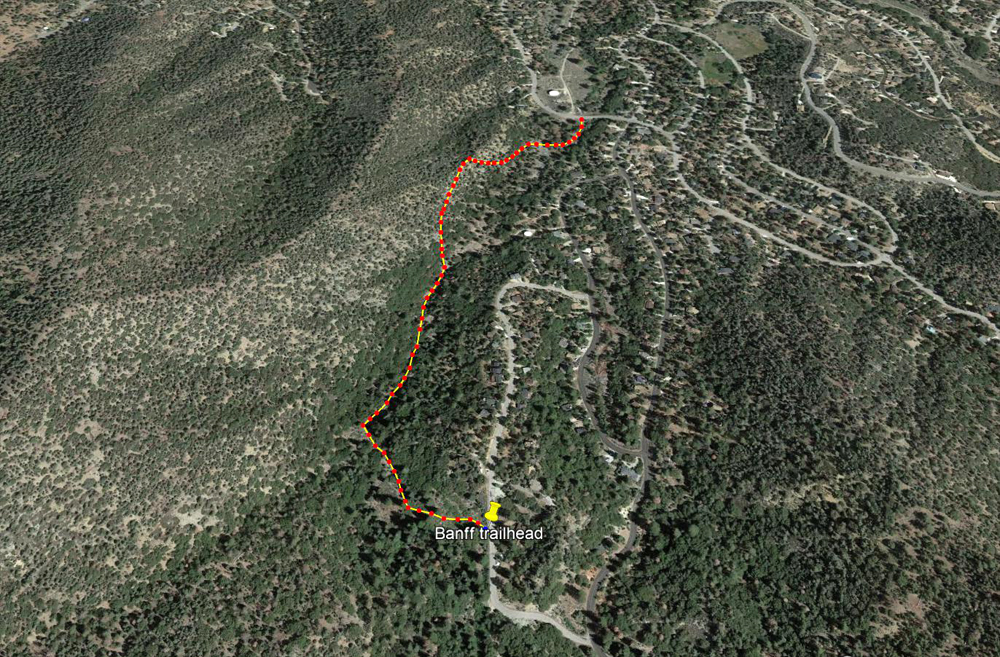
Upper Greenbelt: Banff ⇄ Freeman
This is one of my favorite walks inside the PMC "city-limits". It is just three-quarters of a mile in one direction or 1.5 miles return. It is a very pretty walk in a pleasantly wooded canyon. The gradient is gentle.
If you start from the Banff trailhead, the stroll goes gently downhill the whole way. The reverse direction is gently uphill and not too strenuous.
This greenbelt runs almost the entire length of the town in a roughly north-south direction from the main Mil Potrero highway to the very top of Bernina Drive. The width of the whole town at that point is about one and three-quarter miles and this greenbelt is nearly one and a half miles in length. So it is a substantial greenbelt in relation to the size of the town.....it more or less divides PMC in half. It is possible to walk almost the entire length of this greenbelt on clearly defined trails.
Freeman Drive is the only road crossing this greenbelt which more or less divides the greenbelt in half. This is the same greenbelt where the Snowflake pathways network and community parkland is to be found.
This page describes walking the upper part of this greenbelt which is the prettiest section. You rarely see houses bordering the canyon so it feels like you are in a remote part of the forest and not in the middle of the PMC township.
Banff trailhead:
34° 50' 1.7" North
119° 9' 56" West
The trailhead at Banff descends a steep embankment for a couple of yards from the road level. Go slowly and take care not to slip.
Freeman trailhead (near water tank #D):
34° 50' 30.2" North
119° 9' 49.9" West
Wild animals including bears are occasionally seen in this part of the greenbelt. Encounters are usually at a distance and rarely (if ever) a problem. Please observe the normal precautions and safe practices when walking through the forest. It is best to walk with one or more companions. Animals normally hear you coming and get out of the way. It is a treat if you are lucky enough to see them.
For a longer hike, you can start from the Snowflake pathways network or even from Mil Potrero Highway (i.e. from the pullout near Woodland Drive where there is off-road parking). A chain gate marks the start of the route heading south. A hike between Mil Potrero and Banff is about one and a half miles (one way) or 3 miles return. A hike from the Snowflake pathways to Banff is about one and a quarter miles, or two and a half miles return.
You can also extend your hike beyond (above) the Banff tailhead. Follow Banff Drive (south) around to Bernia Drive and turn right where the road soon ends in a cul-de-sac. Here you will find the trailhead for the very beautiful Enchanted Forest trail through a forest of huge trees.
![]()
Peter Gray
telephone: +1 (661) 242-1234