Jim Whitener Tree
(9th December 2004)
^ ^ ^ ^ The Jim Whitener Tree is found next to Mil Potrero Hwy near Pine Mountain Club.
The typed-letter reproduced below was found in the files at the Ridge Route Communities Museum & Historical Society in Frazier Park, CA. It should be noted that this letter uses the spelling of the finder's name as "Whittner", but I believe the correct spelling is "Whitener", which is also the way his grandson signs his name on this letter. "Whitener" is the spelling used on the sign that used to be on the side of the road marking the spot (see photo below). Also, a newspaper article in The Pine Mountain Pioneer (Oct 21, 1991) entitled "Superior Cones Obtained From Whitener Tree", reports that an original settler of PMC claims to have known Jim personally, and says Jim spelt his name as "Whitener", and not "Whitner" or "Whittner". So I've amended the letter below with what I now believe to be the correct spelling. Here is the text of the letter:
JIM WHITENER TREE
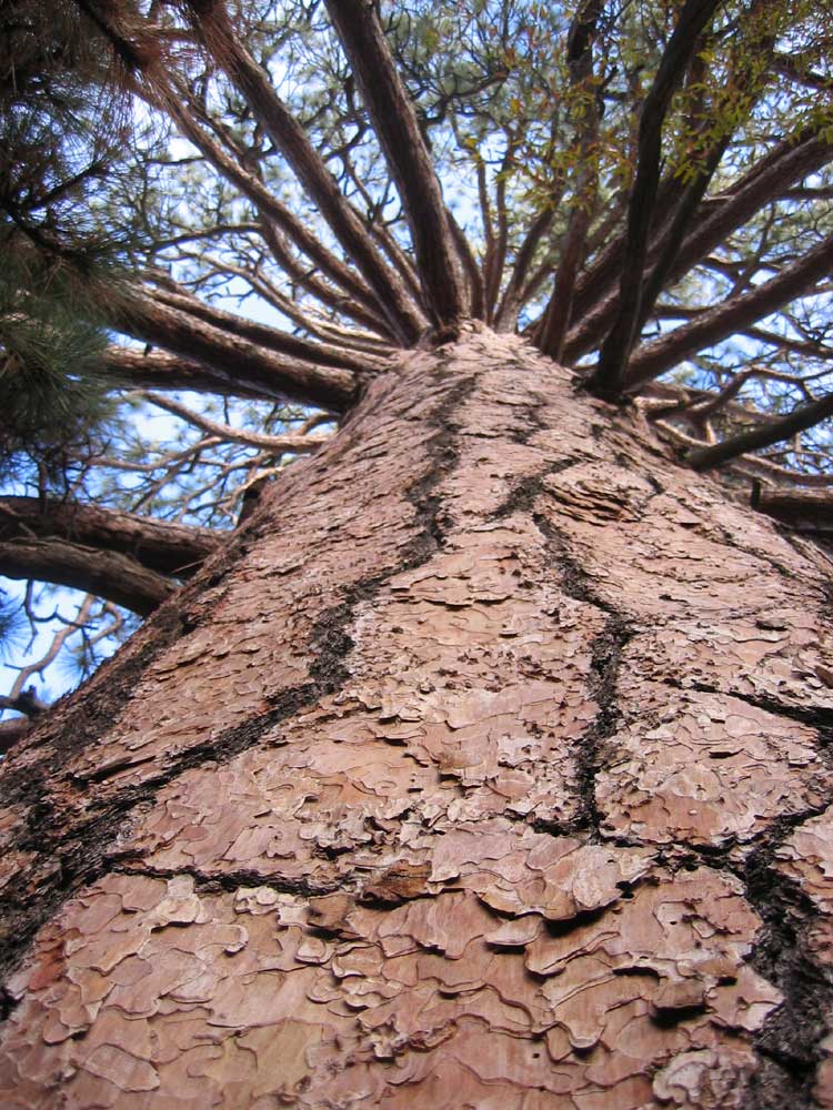
This 142 feet high, 20 foot diameter*** Ponderosa Pine was discovered about 1942 by Jim Whitener, a Forest Service employee on the Cuyama Ranger District. Mr. Whitener worked for the Forest Service 17 to 18 years and retired at age 71. He is now deceased.
He originally homesteaded in the Cuyama Valley and as a FPT (Fire Prevention Technician) he was out on horseback patrol checking the Forest Service phone line running through this area when he discovered this forest giant. Of course at this time the only road in this area was a wagon road which came up San Emigdio Canyon and split - running to Mill Potrero and Cuddy Valley.
At the time Jim worked for the Forest Service he was remembered as being an older man, cowboy type and very tall (6' 4").
The tree was accurately measured in 1958.
This letter is signed by Chris L. Whitener - Grandson, and also D.R. Waugh - Project Forester. There is a third signature, but the spelling of the surname is a indistinct. It may read M. Saugus - Taft. The letter is dated December 7th, 1970.
(*** Note: The mention of a "20 foot diameter" above is a mistake. It should read a 20 foot circumference.)
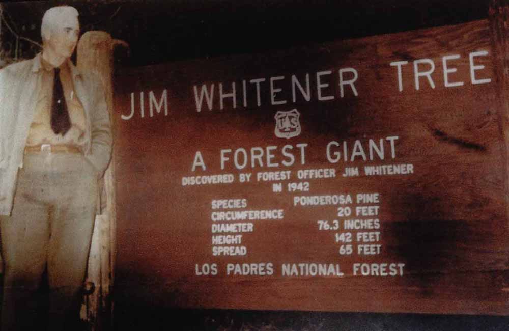
A photo of Jim Whitener taken on the day this sign was dedicated in 1959. This sign was standing on the road (Mil Potrero) near the Whitener Tree, but it is no longer there. The sign read:
JIM WHITENER TREE
A FOREST GIANT
Discovered by Forest Officer Jim Whitener in 1942
Species - Ponderosa Pine
Circumference - 20 feet
Diameter - 76.3 inches
Height - 142 feet
Spread - 65 feet
Los Padres National Forest
I found a source in a hiking guide that says the circumference measured 20-feet 3.5-inches on 14th December 1988 (and the diameter was 6-feet 6.5-inches).
I personally measured the circumference myself in December, 2004 and found it to be 21-feet and 1-inch (taking the measurement about 2 feet above an uneven ground level on the highest side). Seems like the tree has grown a little in the last 16 years.
I would like to thank Curtis Newman, the curator of the Ridge Route Communities Museum, for the copy of this photo and for his invaluable help in finding the information above.
The map below shows the most common hiking route used to reach the base of the Whitener Tree.....
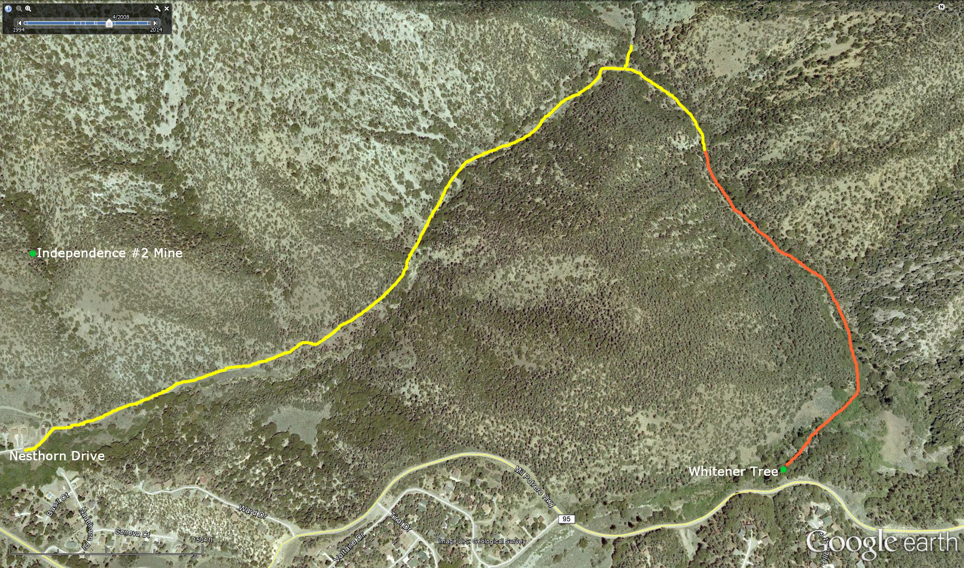
The length of the hike is two and a quarter miles in each direction (4.5 miles total). Park near the end of Nesthorn Drive and continue on foot following the dirt road. Continue on an easy-to-follow route for one and a quarter miles to where the trail splits. Continue straight ahead at the junction and do not turn left (which goes through San Emigdio Canyon and eventually to the main facilities on Wind Wolves). From this junction, you have a further mile to hike to get to your destination (most of it off trail).
Just beyond the junction you will notice a couple of forest giants in pretty groves almost as large as the Whitener Tree. When the trail starts leading you east away from the large hill on your right, you need to leave the trail and make the rest of the way off-trail. Follow the base of the hill by the easiest route you can find until Mil Potrero Hwy is in sight. Refer to the map to give you the approximate location of the Whitener Tree which is quite close to the road high up above. The level of the roadway is about half way up the height of the tree. I discourage anyone trying to scramble down the side of the embankment from the roadway since it is both very high and extremely steep and therefore potentially very dangerous. If you insist on trying to short cut from Mil Potrero, look for easier access (in and out) further west around Glacier Drive.
Even though you seems to be going the long way around, it is a spectacular hike with lots to see and enjoy along the way.
![]()
Peter Gray
telephone: +1 (661) 242-1234